Image
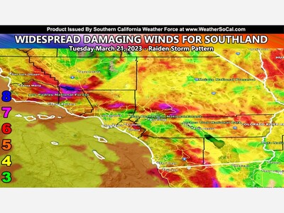
WINTER STORM WARNING REMAINS IN EFFECT UNTIL 7 AM PST TUESDAY... * WHAT...Heavy snow expected. 1 to 3 inches expected between 3000 and 4000 feet, 3 to 7 inches expected between 4000 and 6000 feet, 7 to 10 inches expected between 6000 and 7000 feet, 10 to 12 inches expected above 7000 feet, locally over a foot. Wind gusts 30 to 50 mph. * WHERE...San Bernardino County Mountains. * WHEN...Through 7 AM PST Tuesday. * IMPACTS...Travel could be very difficult. The hazardous conditions could impact the morning or evening commute. I- 15 through the Cajon Pass will be impacted. Strong winds could cause tree damage. * ADDITIONAL DETAILS...Winds will continue through tonight. Snow showers will become more widespread and impactful this evening. Snow levels near 4500 feet tonight, will drop to 3000 feet early Tuesday. Light snow accumulations expected on the I-15 through the Cajon Pass.


Sunny, with a high of 105 and low of 76 degrees. Sunny during the morning, clear for the afternoon and evening,